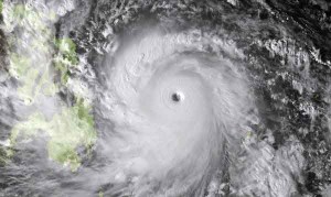
A super typhoon expected to slam into the Philippines on Friday appears on track to become the strongest such storm to develop this year, meteorologists warn. With wind speeds exceeding 190 miles an hour (305 kilometers an hour), super typhoon Haiyan—known as Yolanda in the Philippines—is the equivalent of a Category 5 hurricane in the Atlantic Ocean. Hurricanes, cyclones, and typhoons are all the same rotating ocean storm phenomenon; scientists just call them different names depending on where they occur.
Forecasters predict Haiyan will make landfall on Friday morning in the archipelago’s central islands, many of which are still recovering from a 7.2-magnitude earthquake that struck the region last month. “If Haiyan holds its strength and makes landfall in the Philippines, it would definitely be the strongest typhoon to hit the country this year, and that’s saying a lot,” said Chris Velden, a hurricane expert at the University of Wisconsin-Madison.
“Our advanced satellite algorithms that estimate intensity are hitting values rarely seen.”
Typhoon Season
In the northwestern Pacific, typhoons most commonly develop from late June through December. After a slow start this season, typhoon formation began to pick up in October. “It’s gotten very active again, and now it’s back to where it should be, with several typhoons being spawned a month,” said Velden, whose team uses satellites to track developing storms around the globe. Officials in the Philippines have already begun evacuating people from coastal and landslide-prone regions of the country’s central islands and put emergency workers on alert in preparation for Haiyan’s landfall, according to Reuters.
‘Oversized Tornadoes’
On average 20 typhoons hit the Philippines every year. According to the aid agency Plan International, Haiyan is the 25th typhoon to enter the Philippines Area of Responsibility (PAR) this year. The country happens to be located in a region of the Pacific that, like Hurricane Alley in the Atlantic, is particularly prone to typhoon formation, said Hans Graber, a professor of marine physics at Florida’s University of Miami.
“The waters (in that part of the Pacific) are extremely warm, so with the right atmospheric conditions and steering currents, you have the ideal making of a storm that can eventually develop into a super typhoon,” Graber said. Graber, whose group has studied more than a dozen super typhoons, has noted they possess a curious difference from their Atlantic counterparts. Large hurricanes, or “superstorms,” typically have an inner core that is about 6 to 12 miles (10 to 12 kilometers) wide and generate gale-force winds that extend for hundreds of miles.
Super typhoons, in contrast, appear to be much more compact. “These super typhoons seem to be more like oversized tornadoes,” Graber explained. “Their inner cores are often just a few kilometers wide, and all their high winds are concentrated within a radius of a few tens of kilometers. Beyond that, the wind drops off significantly.”
Eyes Beneath the Clouds
Why super typhoons should have more intense inner wind cores than hurricanes is still not known, since the basic physics that drive a typhoon and a hurricane are the same, Velden said. “Fundamentally, in terms of internal dynamics, acting physics, intensification principles, and decay stages, typhoons and hurricanes are of the same family,” he added. Velden’s team is working with the U.S. National Oceanic and Atmospheric Administration (NOAA) to develop new tools that could provide a clearer glimpse of the eyes and inner dynamics of hurricanes and typhoons. One project that the group is working on will use satellites with improved imaging capabilities to pierce through the storms’ enshrouding cloud layers.
“It’s not just visible and infrared imagery anymore. We’re looking at microwaves and short waves and using combinations of different image channels to deduce some of the properties of these storms,” Velden said. “That gives us eyes beneath the cloud canopy and allows us to see what’s going on in terms of organization, structure, and intensity.”
Seem like Philippines did not have a good run this year, right after the earthquake and this super typhoon. Let’s just hope they are ready and all will be well.


